Query within Range
The Analysis | Query | Range
command  allows you to select, show, or apply properties
to all objects within a specified distance of the selected object's center.
Select only one object to activate this command. If you would like to
select multiple objects, use Draw | Region
| Buffer.
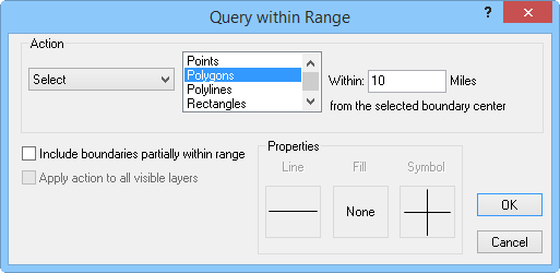
Query within Range Dialog

Query within a specified range from a selected object
to select, show, or edit objects or to create
worksheets, reports, layers, or points with the Query within Range dialog.
Action
In the Query within Range dialog,
you can choose to Select, Show, Apply
Properties, Create worksheet with, Create report with, or Create layer
with the queried boundaries in the Action
group.
Visible
boundaries that fall within the specified distance are selected if
Select is chosen.
If
you select Show, only boundaries
that fall within the specified distance are displayed.
Apply properties to changes the
line properties,
fill properties,
and symbol properties
of the boundaries that fall within the specified distance. If you
have a hatch or territory map, the fill properties do not change the
map since the hatch or territory properties take precedence over fill
properties. Density, pie, bar, symbol, flow, and line graph maps all
show with the specified color fill in the boundaries. The symbol property
change only applies to pin maps. You can specify the queried object
properties with the Line, Fill,
and Symbol buttons in the
Properties group.
Create worksheet with displays
the query results in a worksheet window. The worksheet contains all
of the available data for the boundary objects that meet the query
criteria.
Create report with creates a report
on queried objects similar to a Map
Document Report.
To
create a new map layer of the query results, choose Create
layer with.
Select Create
symbol on to create a symbol on the boundaries meeting the
criteria.
Select the type of object you wish to query (Points,
Polygons, Polylines,
Rectangles, Rounded Rectangles,
Squares, Ellipses,
and Circles) from the list box.
For example, if you selected a county boundary, make sure Polygon
is highlighted to select the areas that fall within the specified
distance of the selected county. Clicking on an object once selects it,
clicking on it again deselects it. You can select multiple objects in
the list by clicking on them once. Check the Include
boundaries partially within range box to apply the action to boundaries
that do not completely fall into the specified distance from the selected
boundary.
Enter a number into the Within
box to define the distance you would like to extend the selection from
the object. The units of the distance depend on what is selected on the
Units page in
the Property Manager.
Query Layers
The Apply action to all visible layers
check box queries all map layers. Check this box to apply the map query
across every layer in the map window.
Data
If you would like to see the data associated with selected objects,
use Analysis | Make
Report | Records Reports | Boundary. Alternatively, you can use Create worksheet with.
See Also
Query
Query Map Data
Boundary Records
Records in Regions
Analysis Tab Commands
 allows you to select, show, or apply properties
to all objects within a specified distance of the selected object's center.
Select only one object to activate this command. If you would like to
select multiple objects, use Draw | Region
| Buffer.