 to create a rectangle region in the plot document.
You can obtain information on selected portions of the map for defined
regions with the Analysis
| Data | Records in Regions command.
to create a rectangle region in the plot document.
You can obtain information on selected portions of the map for defined
regions with the Analysis
| Data | Records in Regions command.Click the Draw | Region | Polygon command
 to create a rectangle region in the plot document.
You can obtain information on selected portions of the map for defined
regions with the Analysis
| Data | Records in Regions command.
Polygons contain two types of properties: line properties and fill properties. You can change these properties in the Property Manager.
To draw a polygon:
1. Click
the Draw | Region | Polygon command
 .
.
2. Move the cross hair cursor over the location for the start of the polygon and click the left mouse button.
3. Move the cursor to the next position along the line and click again.
4. Continue this procedure until you click the final point and then press the ENTER key, or double-click the final point with the left mouse button. Pressing ENTER closes the polygon by connecting the first and last points that were selected regardless of cursor position. Double-clicking the left mouse button places a point where the cursor is located and connects that point to the first point.
5. Press the ESC key to exit drawing mode.

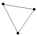
This shows a
Polygon drawn
through three points.
Click points on the page to draw individual points, or click and hold the left mouse button and drag the pointer to draw a continuous stream of points.
Click the right mouse button to remove the last drawn point. This can be done repeatedly.
If the CTRL key is pressed while clicking points, the points are constrained to 45-degree angles.
Double-click the left mouse button or press the ENTER key to close the polygon.
To cancel drawing a polygon, press the ESC key before closing the polygon.
Edit the polygon shape by using the Draw | Tools | Reshape command.
Line and fill properties are set through the Property Manager.
See Also