Closest Neighbor
The Analysis | Evaluate | Closest Neighbor
command  allows you to identify a point object and
search for the closest neighboring point. This command is typically used
on pin maps and other MapViewer
maps created from point objects. In order for the Closest
Neighbor command to be active, at least one point object must be
present on the current map layer. Point objects must have an associated
primary ID in order to be involved in the closest neighbor function.
Find Closest Neighbor Dialog
All the options required to locate the closest neighbor of a point object
are located in the Find Closest Neighbor
dialog.

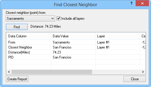
Find the closest neighbor, select starting point, choose
whether to include all layers, and view
point information in the Find
Closest Neighbor dialog.
The
Closest neighbor (point) from
list contains all the points from which you can find the closest neighbor.
The points are listed by primary IDs.
To
search for the closest neighbor across all the map layers, check the
Include all layers box. If
this option is disabled, the closest neighbor search is based on the
active layer only.
Once
you have chosen a point from the Closest
neighbor (point) from list, click the Find
button to identify the closest neighbor. The closest neighbor is identified
and the distance between the two points is reported to the right of
the Find button. For known
projections, the distance units are specified with the Surface
distance units setting on the Units page in the Property
Manager.
The
spreadsheet section of the Find Closest
Neighbor dialog contains all of the available information about
the point. The Data Column
lists the type of data available for the identified closest neighbor.
The corresponding values for the Data
Column are listed in the
Data Value column. The layer
the point is located on is identified in the Layer
column. If you wish to know the precise location of the closest neighbor,
the point's centroid location is listed in the Centroid
(X) and Centroid (Y)
columns. The units of the centroid location are specified with the
Coordinate display units
setting on the Units page in the Property
Manager. To create a report of the closest neighbor data, click
the Create Report button.
See Also
Pin Map
Point
Query
Query Map Data
Query within Range
Analysis Tab Commands
 allows you to identify a point object and
search for the closest neighboring point. This command is typically used
on pin maps and other MapViewer
maps created from point objects. In order for the Closest
Neighbor command to be active, at least one point object must be
present on the current map layer. Point objects must have an associated
primary ID in order to be involved in the closest neighbor function.