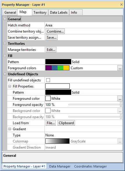
Edit hatch and fill properties, combine, manage, and save territories for territory maps in the Map page of the Property Manager.

Edit territory map properties in the Map page of the Property Manager.
The General group contains options for the display of the map hatching.
Area shows each area as the specified fill color and pattern, or it displays each point and polyline as the specified color.
Circle draws a circle in each polygon, on the polyline mid-line, or on the point and shades it as the specified fill color and pattern.
Square draws a square in each area, on the curve mid-line, or on the point and shades it as the specified fill color and pattern.
If you select Square, set the width of the square in the Width box. If you select Circle, set the circle diameter in the Diameter box.
Click the Combine... button next to Combine territory objects to combine territory objects into a single polygon in the Combine Territory Areas dialog.
Click the Save... button next to Save territory assignments to save territory names and/or numbers to worksheet columns in the Save Territory Assignments to Linked Worksheet dialog.
Click the Save territory number to the following column check box to save the territory number. Select the destination column from the list.
Click the Save territory name to the following column check box to save the territory name. Select the destination column from the list.
Click the View worksheet after operation check box to open the worksheet in the worksheet window after clicking OK.
Map territories on grids, by data classes, or by text classes, or manually
manage the territories in the Territories
dialog. Click the  button next to Manage Territories
to edit territories in the Territories
dialog.
Fill pattern and colors for territories are changed in the Fill
group. Click the Pattern
style to select a pattern in the fill
palette. Click on a Foreground colors
style to select a predefined colormap for the territories. Click the  button to select a custom colormap in the Colormap
dialog.
Click the Fill undefined objects
check box to add fill properties to objects not included in the map territories.
Click the Fill properties option
to edit fill properties.
Select a gradient Type, Colormap, and Gradient Direction to apply a gradient
fill. Clicking the  button near
Colormap opens the Colormap
dialog.
See Also