The scale controls the size of a map or profile on the printed page. This is accomplished by defining a correspondence between lengths on the map (in map units) and lengths on the printed page (in page units). The map scale is specified using the Scale page in the plot properties. The scale for the X axis and the scale for the Y axis can be set in unison (proportionally), or they can be set independently.
Axes are part of the map on which they are drawn. Therefore, when the scale is redefined, the axes are modified accordingly. Because MapViewer calculates reasonable tick spacing based on the map lengths and map limits, redefining the scales can result in different tick spacing along the axis.
When maps using Unprojected Lat/Long are imported, different scaling is used for the X and Y dimensions. This is done to correct for the conversion of the spherical coordinates to the Cartesian coordinate system used to plot maps in MapViewer. For more information on scaling Unprojected Lat/Long maps, see Using Scaling to Minimize Distortion on Latitude/Longitude Maps.
The Scale page is located in the plot properties.
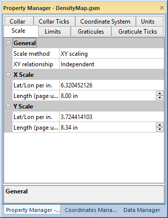
Specify the relative X and Y map scaling on the
Scale page in the Property Manager.
The Scale method list contains XY scaling, Fit to page, and Representative fraction. Select XY scaling to adjust the X or Y scale by Map Units per in. (cm.) or Length.
When Independent is the selected XY relationship property, the X and Y scales can are adjusted independently.
When Proportional is the selected XY relationship property, changing an X or Y scale automatically adjusts the other scale to maintain the map proportion. Both scales have the same Map Unit per in. (cm.) value when Proportional is selected.
When Current is the selected XY relationship property, changing one scale automatically changes the other scale to maintain the current proportion between the scales. The scales do not have the same Map Units per in. (cm.).
The Scale method list contains XY scaling, Fit to page, and Representative fraction. Select Fit to page to fit the map scale to the page.
If the XY relationship property is Proportional, the scale will be increased to fit the smaller page dimension. The Map Units per In. (cm.) values will be the same for the X and Y scales.
When Independent is the selected XY relationship property, the X and Y scales are fit to the page dimensions independently.
If the XY relationship property is Current, the current scale proportion is maintained while one scale is fit to the maximum page dimension.
The Scale method list contains XY scaling, Fit to page, and Representative fraction. When Representative fraction is selected, the Scaling ratio property determines the map scale in the form of 1:N (1 page inch/centimeter : N map inches/centimeters). The page units (inches or centimeters) are set on the General page of the Options dialog. Since the ratio is dimensionless, the value will be the same whether the page units are inches or centimeters.
The Map units per in. (cm.) option sets the number of map units per page unit in the associated dimension. For example, to draw a map at a scale of 1000 map units per inch, type the value 1000 into the box. The Length (page units) value is automatically updated to reflect the change. For example, if the map is 8000 units in the dimension you are setting, the map is 8 inches long in that dimension.
The Length (page units) option sets the length of the map in the X, Y, or Z dimension. When the Length (page units) value is changed, the Map units per In. (cm.) box is automatically updated to reflect the change.
Sizing a map with its selection handles does not rescale the map internally, it just resizes the map on the screen. To return to the proper scale, use the Scale page to scale the map. Sizing a map with the Map | Layer | Move/Size All Layers command changes the internal map scale.
See Also
Using Scaling to Minimize Distortion on Latitude/Longitude Maps