 button, to import
graphic "trim" objects, background graphics, or some form of
annotation. Use Map | New
| Base Map to import boundary information suitable for overlaying
on top of other map types.
button, to import
graphic "trim" objects, background graphics, or some form of
annotation. Use Map | New
| Base Map to import boundary information suitable for overlaying
on top of other map types.You can import graphic files in MapViewer with the File | Import command. The File | Import command is similar to the Map | New | Base Map command except that the file is imported as a grouped graphic object rather than as a map.
Click the File | Import command,
or click the button, to import
graphic "trim" objects, background graphics, or some form of
annotation. Use Map | New
| Base Map to import boundary information suitable for overlaying
on top of other map types.
The File | Import command in the plot opens the Import dialog.
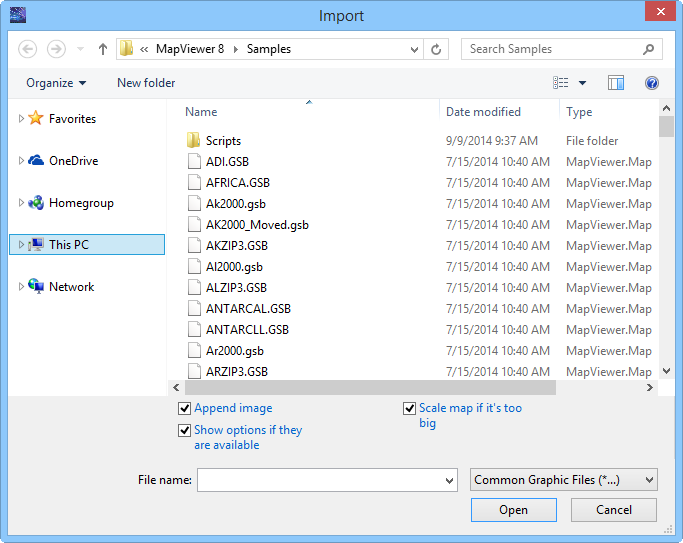
Specify files to import using the Import
dialog.
The Look in field shows the current directory. Click the down arrow to see the directory structure. Click on the folders to change directories.
Creating New Folders and Changing the View
The buttons to the right of the Look in field allow you to create new folders and change the view of the file list.
File List
The file list displays files in the current directory. The current directory is listed in the Look in field. The Files of type field controls the display of the file list. For example, if Golden Software Boundary (*.GSB) is listed in the Files of type field only .GSB files appear in the files list. To see all files in the directory, choose All Files (*.*) from the Files of type list. Double-click on a file to open it or single-click the file and then click the Open button.
The File name field shows the name of the selected file. Also, a path and file name can be typed into the box to open a file.
The Files of type field shows the file format to be opened. To change the file format, click the down arrow and select the file type from the list.
The Common Graphic Files (*...) format type is selected by default. This displays all the file formats that can be imported with File | Import in the navigation pane. If a different format type is selected, Surfer will remember the setting until the end of the current session. When Surfer is restarted, the default format type will be used.
To see all files in the directory, choose All Files (*.*) from the Files of type list. Double-click on a file to open it or single-click the file and then click the Open button. The All Files (*.*) option shows all of the file formats in the current directory, even if the file type is not appropriate for the action chosen.
The File | Import command in the plot document opens the Import dialog. In the Import dialog, select one of the following formats to import data into the worksheet.
To open Golden Software Blanking .BLN and Atlas Boundary .BNA files in the worksheet use File | Open rather than File | Import.
Images are typically imported into MapViewer as a base map.
Where applicable, MapViewer automatically imports all available attribute information.
See Also