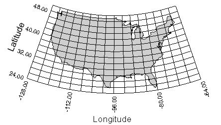
Graticule lines are lines of constant longitude (X coordinate) or latitude (Y coordinate). Longitude lines are also called meridians, and latitude lines are also called parallels. Graticule lines can also be based on other coordinate systems.
Graticule lines reflect the map's coordinate system.
The Map | Add
| Graticule command  displays or hides map coordinate grid lines. The graticule is based on
the map coordinate system and
are not page coordinate grids. For projected coordinates, the graticule
lines can curve to follow the projection (for example, on an Albers projection),
or can show different spacing in the north-south dimension (for example,
on a Miller projection). For maps using Unprojected Latitude/Longitude
or any Unknown coordinate system,
a rectangular grid is drawn. Only one map layer can contain graticule
lines.
displays or hides map coordinate grid lines. The graticule is based on
the map coordinate system and
are not page coordinate grids. For projected coordinates, the graticule
lines can curve to follow the projection (for example, on an Albers projection),
or can show different spacing in the north-south dimension (for example,
on a Miller projection). For maps using Unprojected Latitude/Longitude
or any Unknown coordinate system,
a rectangular grid is drawn. Only one map layer can contain graticule
lines.
MapViewer plots the graticule on the active layer at the time the Map | Add | Graticule command is clicked. When the layer with the graticule is deleted, the graticule lines are moved to the new active layer. If the active layer contains a prism map, then MapViewer searches the from the bottom layer to the top layer and assigns the graticule to a non-prism map layer. If all layers are prism map layers, then the graticule is not drawn.
The graticule state is displayed in the Object Manager and ribbon bar.
In the Object Manager the show/hide
eye has a graticule icon in the top right corner  .
The Map | Add | Graticule command
stays highlighted when the active layer contains the graticule to indicate
the graticule is drawn.
.
The Map | Add | Graticule command
stays highlighted when the active layer contains the graticule to indicate
the graticule is drawn.
There are several ways to remove the graticule from the map.
When the active layer contains the graticules, click the Map | Add | Graticule command.
In the Graticules page of the Property Manager, uncheck the Show graticules boxes in the X Graticules and Y Graticules sections.
Clicking
the button in the Object
Manager hides the layer containing the graticules without removing
them.
The legend and post map text is always plotted on top of the graticule lines on that layer. Graticules are not drawn on prism map layers.
When you have a graticule displayed on a map and want to copy the map to the clipboard, you must use the Copy All Layers command. This command is the only way to copy the graticule along with the map. Otherwise, only the map is copied and the graticule lines are not included with the copied image.
The plot properties contain Graticules and Graticule Ticks pages in the Property Manager when graticules are displayed on one of the map layers. Show the plot properties in the Property Manager by clicking the Map | Plot | Plot Properties command or clicking white space in the Object Manager. See the Graticules and Graticule Ticks help pages for information on editing graticule properties in the Property Manager.
See Also
Introduction to Map Projections
Latitude/Longitude Coordinates
Latitude/Longitude in Decimal Degrees
Using Scaling to Minimize Distortion on Latitude/Longitude Maps