Latitude and longitude are spherical coordinates used to locate a point on the earth. Many maps do not need to take the curvature of the earth into account. For maps covering relatively small land areas, such as a state or small group of states, the earth can be assumed to be flat. In these cases, the latitude/longitude coordinates can be plotted on a Cartesian coordinate system. Maps plotted in this way must use different scaling in the two dimensions to minimize distortion on the map. MapViewer makes a simple adjustment when importing files containing latitude/longitude coordinates to compensate for the spherical to Cartesian coordinate conversion. This is referred to as an Unprojected Lat/Long map. The adjustment alters the aspect ratio slightly so the map does not appear stretched out horizontally. For more information, see Using Scaling to Minimize Distortion on Latitude/Longitude Maps. For larger areas, the curvature of the earth should be taken into account. For these purposes, the map can be plotted using a projection.
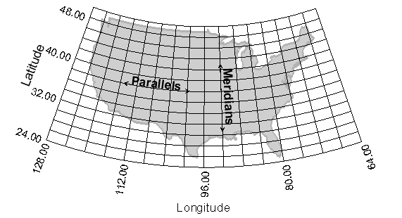
Parallels define lines of constant latitude, and meridians define lines of constant longitude.
This Albers projected map makes use of graticule lines to indicate the relationship.
Latitude
Latitude is the Y coordinate and defines north-south global position measured from the equator. Lines of constant latitude are called parallels because they define a series of rings parallel to the equator. Parallels run east-west, but define north-south position on the globe. Parallels are designated in degrees from 0° at the Equator to 90° at the poles. MapViewer uses the convention that parallels are positive north of the equator (north latitudes), and negative south of the equator (south latitudes). Designations such as 45° indicate a position 45 degrees north of the equator, while -65° indicates a position 65 degrees south of the equator. At any position on the globe, the distance covered by a degree of latitude remains nearly constant.
Longitude
Longitude is the X coordinate and indicates east-west position on the globe. Lines of constant longitude are called meridians. Meridians lie at right angles to the parallels and are half-circles drawn from the North Pole to the South Pole. One meridian is designated as the prime meridian. The prime meridian most commonly in use in the United States runs through Greenwich, England, although there are several other prime meridians in use throughout the world. Longitude is measured 180° east and 180 degrees west from the prime meridian. In MapViewer, longitude is positive east (east longitude) of the prime meridian, and negative west of the prime meridian (west longitude). A designation such as -105° is used to indicate a location 105 degrees west of the prime meridian. Meridians converge at the poles so the distance covered by one degree of longitude decreases as you move north or south from the equator.
MapViewer only plots latitude and longitude coordinates in decimal degrees. You can see Latitude and Longitude Coordinates in Decimal Degrees for information on converting degrees-minutes-seconds to decimal degrees.
See Also
Introduction to Map Projections
Latitude and Longitude in Decimal Degrees
Using Scaling to Minimize Distortion on Latitude and Longitude Maps