Specify the map coordinate system on the Coordinate System page.
Maps can be displayed in any coordinate system. The map is displayed in the coordinate system defined as the Target Coordinate System for the map. A coordinate system normally has a defined projection and datum. If some map layers are using a different source coordinate system than the map's target coordinate system, the map layer is converted to the map's Target Coordinate System. The map's Target Coordinate System is the new coordinate system that you want to use to project your X, Y coordinate data.
When a new plot is created, the plot and layers of the plot are set to an unreferenced coordinate system.
The Coordinate System page is located in the plot properties. Pin maps have a separate data coordinate system. Edit the Data Coordinate System in the Coordinate System page of the Property Manager for a pin map.
Specify the map coordinate system on the Coordinate
System page.
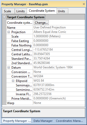
Click the Change button next to Coordinate system to open the Assign Coordinate System dialog. This dialog lets you set the desired target coordinate system. This is the coordinate system in which you want the map to be displayed.
Projection and Datum information is displayed for the current Target Coordinate System on the Coordinate System page.
See Also