Measure Distance
The Analysis | Distance | Measure Distance
command  allows you to measure the distance between
points on a map. Once the Measure Distance
command is selected, you can click multiple points on a map to measure
distance or you can hold the left mouse button down and drag the mouse
to measure distance. The distance is displayed near the cursor and in
the status bar. Right-clicking the mouse removes the last point and subtracts
the distance from the total.
allows you to measure the distance between
points on a map. Once the Measure Distance
command is selected, you can click multiple points on a map to measure
distance or you can hold the left mouse button down and drag the mouse
to measure distance. The distance is displayed near the cursor and in
the status bar. Right-clicking the mouse removes the last point and subtracts
the distance from the total.
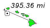
Measure Distance tracks distance
as you move your cursor.
Distance Units
The distance units are set on the Units
page in the Property
Manager. If your map has unknown units, page units will be displayed.
You can use Map | Calibrate | Calibrate
to change into known units.
Multiple Measurements
You can continue making measurements while the Measure
Distance command is selected. Press ENTER on your
keyboard or double-click with your mouse to make a new measurement. When
you start a new measurement, the distance line and distance measured are
removed from the screen. When you are finished measuring, press ESC.
Saving the Distance Curve
To save the curve created with the Measure
Distance command, check the Save
line after measuring distance option in the User
Interface page of the Options
dialog.
See Also
Distance of Travel
Shortest Path
Tabulated Distance
Analysis Tab Commands