Before we begin with the tutorial, let's consider the components of a MapViewer thematic map. To create a thematic map in MapViewer, you need both a base map containing boundaries and a data file containing the data you want to represent on the map. With these two components, you can create any of the thematic map types.
Base maps consist of areas, curves, and points. Areas, curves, and points are also referred to as boundary objects. Areas (polygons) are closed shapes that can display some type of fill property. Curves (polylines) are a connected set of points forming either straight or curved lines. Points consist of a symbol marking an XY coordinate position. MapViewer thematic maps link data to areas, curves, or points on the map. Areas, curves, and points are linked to data by using what we call primary IDs. A primary ID is a unique identifier associated with each area, curve, or point to be represented on the thematic map. This primary ID is also found in the corresponding data.
The data contains the primary IDs and the information for each area, curve, or point you would like to represent graphically on a map. Each row in the data contains the primary ID and the variables (data) for a single boundary object on the map. Each row has the specific data values for the linked object and each column contains the different data variables. For example, column A in your data file could list the primary IDs for each area on the map, and column C might list population values for all the objects on your map.
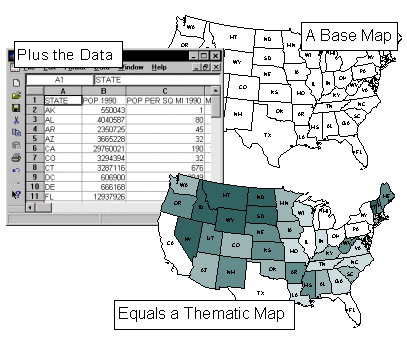
The graphic shown here illustrates the relationship between map boundaries and worksheet data. Notice that the primary IDs are displayed for each area on the map and are also contained in column A of the worksheet portion shown.

This graphic illustrates the relationship between the base map and the data when creating a thematic map in MapViewer. Each map area (the states) shows the primary ID (the two letter state designation). These primary IDs are also contained in column A of the data file shown here. The data are linked to the areas on the map to create the population hatch map shown in this example.
See Also