Shortest Path
The Analysis | Evaluate | Shortest
Path command  measures
the shortest distance between selected points on the map. You can select
a point to start the measurement, or MapViewer
can determine the shortest path. A report of the total distance and distance
traveled between points can be generated with this command. Before using
Analysis | Evaluate | Shortest Path,
select points on the
map.
measures
the shortest distance between selected points on the map. You can select
a point to start the measurement, or MapViewer
can determine the shortest path. A report of the total distance and distance
traveled between points can be generated with this command. Before using
Analysis | Evaluate | Shortest Path,
select points on the
map.
Shortest Path Dialog
You can specify the beginning point or shortest path, display of coordinates,
and display of travel path using the Shortest
Path dialog.
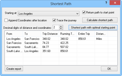
Select the starting point and other options, generate
reports, and view the shortest path between
points in the Shortest
Path dialog.
Select
the Starting at point or
click the Shortest Path With Optimal
Starting Point button to generate the path.
If
the Append coordinates after location
box is checked, the point's coordinates are reported next to the primary
ID name in the distance of travel report.
Set
the number of digits to the right of the decimal place in the Decimal digits of distance and coordinates
box.
Check
the Trace the journey check
box to show a line on the map indicating the travel route. In the
Object Manager,
the travel route's secondary ID (SID) displays the starting point
along with the total travel distance.
Click
the Calculate Shortest Path
button to generate the distances between the primary IDs you have
selected.
The
grid at the bottom of the dialog contains the From
and To primary IDs for each
travel segment, the segment Trip
Distance, the Running Total
distance, the Entire Trip
distance, and the Distance Units.
The units are set in the Units page in the Property
Manager.
Click
the Create Report button
to create a report of travel distances. The report contains a report
time and date, the distance between points, the entire trip distance,
and the units of the distance measurement. The units are set in the
Units page in the Property
Manager.
See Also
Measure
Distance
Tabulated Distance
Distance of Travel
Analysis Tab Commands