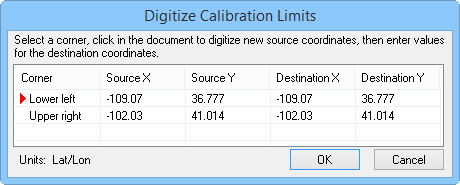
During recalibration with the Calibrate command, the Digitize Calibration Limits dialog sets the lower left and upper right calibration points. This imposes new map coordinates on the screen. The calibration limits for unprojected maps are in Lat/Lon units. For projected maps, the calibration limits are in Meters.
Edit Source and Destination coordinates in the Digitize Calibration Limits dialog.
First, click on a row to edit, the Upper right row or the Lower left row. The existing map coordinates appear in the Source X and Source Y boxes.
If you do not want to use the pre-selected calibration point, indicated by a cross in the plot window, click the new calibration point on the map. The Source X and Source Y fields for the selected Corner change to the new calibration point.
Next, enter the desired X and Y coordinates into the Destination X and Destination Y fields. Repeat the process with the next row.
Click OK to change the map calibration.
See Also