Intersect Polygons
The Boundary | New Boundaries | Intersect
Polygons command  creates a new boundary
from two or more intersecting boundaries. The area that intersects all
selected boundaries is the new area. The original areas outside of the
intersecting portion are removed. You can apply a unique line style to
the new traced boundary for emphasis, and assign a primary
ID to the new area so you can link it to data. If none of the selected
boundaries overlap, a new boundary is not created.
creates a new boundary
from two or more intersecting boundaries. The area that intersects all
selected boundaries is the new area. The original areas outside of the
intersecting portion are removed. You can apply a unique line style to
the new traced boundary for emphasis, and assign a primary
ID to the new area so you can link it to data. If none of the selected
boundaries overlap, a new boundary is not created.
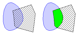
Use
the Intersect Areas command to
create a new
area
(green on right) from
intersecting areas (left).
To use the Intersect
Polygons command:
1. Select
all the areas that define the boundary of overlapping areas.
2. Choose
the Boundary | New Boundaries |
Intersect Polygons command.
3. Select
options for the original areas and lakes in the Intersect
Areas dialog.
4. Click
the OK button and the intersecting
area is created.
Intersect Areas Dialog
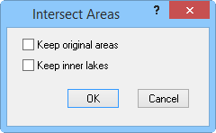
Select whether to keep original areas and/or
lakes in the Intersect
Areas dialog.
Keep Original Areas
When Keep original areas is
activated, the intersection of the selected areas is traced to create
a new area while leaving the original selected areas unchanged. When Keep original areas is NOT activated,
the areas are used to create a new area, and the original group
is deleted.
Keep Inner Lakes
When Keep inner lakes is
activated, inner boundaries, called lakes, are included in the new traced boundary. When
Keep inner lakes is not activated,
inner boundaries, called lakes, are removed from the new traced boundary.
See Also
Combine
Islands
Selecting
Objects
Union of Areas
Difference of Areas
Enclose
Boundary Tab Commands