 allows you to create a buffer (outlined boundary)
around the selected objects. Once a buffer zone is created, you can query
the buffer zone with Analysis
| Query or analyze the region with Analysis
| Data | Records in Regions.
allows you to create a buffer (outlined boundary)
around the selected objects. Once a buffer zone is created, you can query
the buffer zone with Analysis
| Query or analyze the region with Analysis
| Data | Records in Regions.The Draw | Region | Buffer command
allows you to create a buffer (outlined boundary)
around the selected objects. Once a buffer zone is created, you can query
the buffer zone with Analysis
| Query or analyze the region with Analysis
| Data | Records in Regions.
Before using this command, select points, polygons, and/or polylines on the map or in the Object Manager.
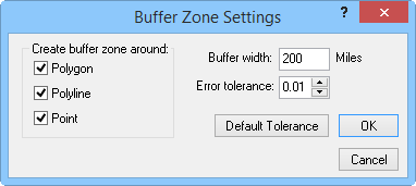
Create a buffer zone with the Buffer Zone Settings dialog
Check object types (Polygon, Polyline, and Point) to select around which objects the buffer zone will be generated.
Set the distance around the selected polygons, polylines, or points in the Buffer width box. The units of the Buffer width are set in the Property Manger
Set the error tolerance for the buffer zone by typing in the Error
tolerance box or using the  button. The error tolerance must be between 0 and 0.5. Pressing
the Default Tolerance
button sets the error tolerance to 0.01.
button. The error tolerance must be between 0 and 0.5. Pressing
the Default Tolerance
button sets the error tolerance to 0.01.
After the OK button is clicked in the Buffer Zone Settings dialog, a red dotted line is drawn surrounding the original selected boundaries, and a second red dotted line is drawn at the specified buffer width from the selected boundaries. The buffer zone is the area between the selected boundaries and the buffer width line, shown in blue below. The buffered area is the original selected boundaries.

The buffered area contains the originally selected areas. The
buffer zone is the area drawn around the originally selected
areas. You can also create buffer zones around points and curves.
Clearing Buffer Zones
To remove all buffer zones, select the Draw | Region | Clear command.
See Also