Right-click on any server name in the Download Online Maps dialog and select Info to check the connectivity of the server.
The server location is tested and the results of the test are reported.
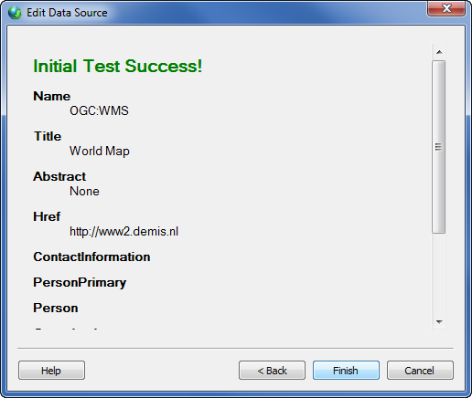
The program initiates communication with the server. If the communication is successful, an Initial Test Success message appears. The dialog will contain information, such as name, title, and location, for the server. Different servers will have different information available. Click OK to return to the Download Online Maps dialog.
If the program cannot communicate with the server, an Initial Test Failed message appears. The program is unable to connect to the server. There are a variety of reasons this could happen. The web server URL could have changed or could be input incorrectly, the web server is temporarily down, a firewall or virus scanner is preventing the program from connecting to the server, or an internet connection cannot be established. Sites with https:// or sites that redirect to SSL servers are not currently supported.
Below the Success or Failure message, additional information about the server appears. This will include the Name, Title, and HRef at a minimum. It can also include Abstract, Keyword List, Contact Information, Layer Limits, Maximum Width, Maximum Height, Fees, and Access Constraints.
The Name option lists the type of server. Currently, this is always WMS.
The Title option lists a brief yet descriptive description of the server. This is created by the server provider.
The HRef option is the website URL that hosts the server.
The Abstract option is similar to the Title option, however the description can be longer and in narrative format. This is created by the server provider.
The Keyword List is a list of keywords or phrases that describe the server as a whole. Keywords can include definitions. For example, a server could show a vocabulary attribute that is defined by an organization such as the International Standard.
The Contact Information can include name of the contact person, physical address, email address, organization name, country, or position.
The Layer limits section includes the maximum number of layers a client is permitted to include in a single GetMap request.
The Maximum Width or Maximum Height option can contain the maximum allowed width or height values for a downloaded image.
The Fees section includes usage costs for the server.
The Access Constraints section can contain any limitations on usage of the server.
Click Help to open the online help file with information about the open dialog.
See Also