Hatch maps and territory maps use the Color Spectrum dialog to assign map colors based on data. The color spectrum has specific colors assigned to nodes along the spectrum. After you create a color spectrum, you can save the spectrum for later use with other maps. A number of predefined color spectrums are included with MapViewer.
Select the color spectrum for hatch and territory maps in the Color
Spectrum dialog.
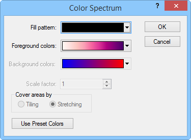
The Color Spectrum Dialog
Click the Fill button in the Data Classes or Text Classes dialog to open the Color Spectrum dialog.
Click the Foreground Colors button to select the color spectrum for solid patterns and for the lines in non-solid patterns.
If you have selected a pattern other than Solid, a Background Colors button is available. Click this button to assign background fill colors.
Click the Fill Pattern button to apply a fill pattern to the map.
When
the Fill Pattern is a selection
other than Solid, adjust
the Scale factor for the
pattern by typing a value in the Scale
factor field or clicking the  buttons.
Also when a non-solid pattern is selected, the pattern can be tiled or stretched by selecting Tiling or Stretching in the Cover areas by group respectively.
With territory and hatch maps, you can click the Use Preset Colors button to assign a fixed list of foreground colors to the classes rather than assigning the color spectrum colors.
See Also